Category: Uncategorized

How to troubleshoot laser scanner surveys

During a laser scanner survey there are many problems which you may encounter and which can compromise the final result of the scan.

Let's see what they are and how it is possible to avoid them starting from a good strategic analysis of the area to be scanned.

What are the problems that can arise during a laser scanner survey?

Each area to be treated is different from the others, for this reason it is not possible to think of preparing each scan in the same way. Here are the ones most common problems that emerge during a laser scanner survey.

Environmental and climatic conditions

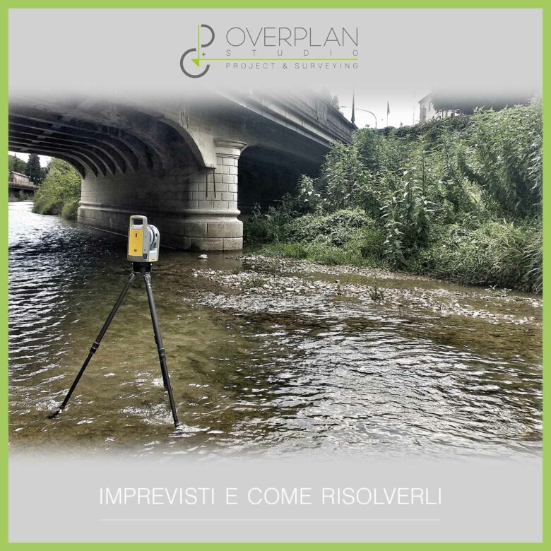
  • There conformation of the area to be scanned is one of the first obstacles that comes up before professionals. The area can in fact be cluttered by natural or artificial elements which can obstruct the scanner's field, compromising the success of the scan.
  • Also to be taken into consideration is the climate of the area, which must not be humid, windy or rainy.
  • Another element that can create problems during a laser scanner survey is the presence of people inside the site, because these can create shadow areas that compromise the scan.

Characteristics of the building or object to be scanned

  • Another element that can create problems during surveys is the composition of the object to be scanned, which may present irregularities, difficult or narrow areas but also transparent or excessively reflective areas.

Lack of a strategy

  • In addition to the conditions of the environment and the building to be scanned, one of the main problems that can arise during a laser scanner survey is the lack of a strategy and in-depth analysis of the territory. Only through an analysis and a strategy can we choose the most suitable tools to use and the best way to work to avoid errors or invalidate the scan.

Solutions to laser scanner surveying problems and unforeseen events

Obviously It is not always possible to remedy any unforeseen events, but there are some good practices and advice to follow to make the survey free from errors and problems. Let's see what they are.

1. Perform analysis and strategy before scanning

Perform an accurate strategic analysis of the area and object to be scanned before of the survey allows you to choose the solutions to make the work as simple and accurate as possible, such as:

  • More suitable equipment to avoid problems during the survey;
  • Number of people required on site;
  • Area where to place the scanners;
  • Any accessories, such as targets, and where to place them.

2. Use specific accessories and combined instruments

Regarding the choice of accessories and equipment There are some elements that allow you to make the survey even easier.

For example, there are the target with ID, The spray which make excessively shiny or transparent surfaces opaque, but above all they can be used multiple laser scanners with different features in synergy with each other to perform scans of complex areas or objects. 

One last tip for the instrumentation is to use cutting-edge technologies as BIM, Artificial intelligence or Augmented Reality to carry out scans, so as to be able to monitor any structural modifications or changes without having to carry out further surveys.

3. Increase the communication speed between instrument and software

In addition to the basic advice of keep an eye on the weather before carrying out a laser scanner survey, to avoid problems due to the climate the solution is to use instruments capable of communicating quickly with the relevant software.

In this way the information passes directly from the instrument to the PC and data obtained during scans can be saved even in the event of sudden disturbances.

Is carrying out a laser scanner survey a cost or an investment?

THE topographic surveys are still seen today as unnecessary costs on which to try to save as much as possible, but a well done laser scanner survey is essential for the success of the project and has numerous advantages for the client.

Let's see why it should be considered a investment and not a cost.

The importance of taking surveys correctly

Very often during the initial stages of a project to save costs avoid using technological solutions, because in the immediate future they are more expensive.

In particular, it is chosen to Do not use laser relief scanner Why too expensive and why extracting a complete and accurate point cloud, with the right degree of detail, can take time.

Laser scanners are therefore preferred other technologies, more fast but less innovative, without realizing that however a A well-made survey is essential right from the design stage of the building, to avoid errors during the design phase or worse, construction site shutdowns due to any problems.

The costs of a laser scanner survey

How much does it cost actually make a laser scanner survey?

The cost can vary based on different factors, such as the size and type of area to be scanned, the number of points needed for scanning, and the type of point cloud to extract (2D or 3D).

In general we start from around €1000 to even €30,000, based on the area to be surveyed.

For this reason it is always it is necessary to carry out inspections to understand the work to be done and the type of technology to be used to obtain a point cloud complete with all the information necessary for the project.

The disadvantages of saving on the survey

Choosing to save on the reliefs it may seem like a convenient choice, which allows you to save money, but you do not realize the risks that you may encounter.

  • A low cost can mean inadequate technologies to carry out the surveys or personnel not qualified to carry out the work correctly;
  • Making reliefs with traditional techniques always has a certain margin of error and personal interpretation, which can lead to problems on the construction site;
  • Risk of making mistakes, causing slowdowns or worse moments of stop in the construction site and redesigns.

The consequence of all this is a suboptimal work management, with an obvious increase both the timing and costs of the project.

The advantages of laser scanner surveying

On the contrary, to make a survey with the best technologies and the correct one level of detail allows you to:

  • To carry out surveys in short time and with less manpower;
  • Obtain precise and detailed drawings even of complex buildings and particularly large areas or with areas that are difficult to access;
  • Having a tool available to designers right away complete picture of the work to be done;
  • Speed up and optimize work both in the design phase and on construction site;
  • Making the right decisions even in critical phases of the project.

It is clear how all these advantages go to offset the initial cost of the laser scanner survey, allowing you to save on project management time and costs, thus making the the expense made was a real investment.

Using BIM for Construction Site Management? Here are the Benefits

In an increasingly digitalized construction sector, the BIM plays a fundamental role in theprocess optimization. We have seen how we can exploit the BIM in synergy with the laser scanner to obtain a digital, 3D and optimized model of the building, but what are the advantages of using BIM on construction sites?

The reality of the construction site

The shipyard is a multidisciplinary reality, in which very different professional figures collaborate.

For this reason it is essential that there is always the right level of collaboration and of work organization, to ensure a linear trend of the jobs and the correct execution of the work.

Until recently, construction site work, time management, changes to be made to the work, etc. were processes managed in paper mode and with minimal digital media, but this method brings with it numerous disadvantages, including the transcription errors of the changes or the lack of communication between team members, which result in the slowing down or blocking of work.

A space to manage the construction site, the BIM

For optimize work management, to organize the team and improve communication between the different professional figures it is necessary to let go of paper and have a unique virtual space available where to find all the information relating to the work and be able to share it.

This space is the BIM, which brings numerous advantages to the construction site in the design phase and during the actual execution phase, both for the construction of the work and for the safety of workers on the construction site.  

As we said, BIM is a digital model that contains all the information relating to the work and its life cycle. At the construction site this information is used to:

  • Organize the work in advance and the management of timescales and deadlines;
  • To realize that any errors and changes to be made first that the project be started;
  • Have a general overview of the progress of the works;
  • Know at every stage of project execution type and quantity of materials needed for subsequent phases to anticipate management with suppliers;
  • Keep track of all changes made since the beginning of construction;
  • Optimize the progress of work and communication between the different professional figures.

Create a BIM model of the construction site

Not only that, with BIM it is also possible to create a digital model of the construction site itself, which keeps track of:

  • Features of the territory of the construction site with the urban context and its critical issues;
  • Professional figures involved in the construction site;
  • Machinery and technologies available.

Having a BIM model of the construction site allows you to:

  • Manage jobs in an innovative way;
  • Organize and optimize the design phase and executive phase;
  • Effectively manage the space inside the construction site;
  • Eliminate errors and resolve problems before they arise;
  • Ensure the worker safety through the creation of objects containing information on correct installation methods and safety management.

All this allows one linear, rapid and optimised work progress, resulting in savings on costs and time and greater protection of the work team.

Tips for extracting 3D models efficiently from point clouds 

Using Scan to BIM to obtain a 3D model from the point cloud may seem like a simple process, but it hides numerous pitfalls, especially if you do not follow the right advice.

Let's see what are the tips to extract functional 3D models from the point cloud and optimize the processes.

Scan to BIM and the point cloud

Being able to extrapolate a 3D model starting from the point cloud This means no longer having to create a 3D model of the work from scratch, making the procedures simpler and faster.

This is possible through the Scan to BIM methodology, which allows you to create a 3D version of the work As Built, containing all the information relating to the project and its life.

To do this, you need to have BIM software available, capable of recognizing the elements present in the point cloud and converting them into three-dimensional objects complete with all the information.

How to extract a quality 3D model from the point cloud

Extracting a 3D model from a point cloud can be a source of pitfalls right from the start of data collection. How can you streamline the process and get quality 3D models?

Starting from an effectively carried out survey

The first step to obtain a quality 3D model starting from the point cloud is to create a good laser scanner survey, with quality equipment and capable technical staff.

In this way the survey will be faster, more complete and above all easier to process and transform into a point cloud. 

Having the right tools available

Once the survey has been completed, the cloud can be processed using point cloud management software.

As we know, the cloud after the survey can be easily implemented and modified, to create a model with all the necessary data.

To obtain a digital model based on the point cloud, latest generation software is needed, which allows you to:

  • Get the 3D model quickly and in a few steps;
  • Have a detailed and accurate model;
  • Avoid wasting time on site inspections because the point cloud always serves as a reference for the 3D model.

The advice is to use these tools intelligently, avoiding automating everything. It is better to prefer semi-automatic tools, which allow manual changes to process data, thus saving time and limiting the margins of error of automation.

Select only the necessary data

Very often it is mistakenly thought that the more data is inserted into a 3D model, the more valid and efficient it becomes. The reality is different, in fact not all the data collected is always necessary, but above all collecting a large amount of data when it is not necessary also implies an increase in the time and costs of scanning

The advice, starting from the survey phase, is to collect only the data you need, or those necessary for the level of detail agreed with the client. This is essential for:

  • Respect the customer's needs;
  • Reduce scanning times;
  • Speed up the process of importing data into software;
  • Speed up model creation.

Not only that, collecting and selecting only the necessary data allows you to choose the right level of detail needed for the model and avoid overloading the file excessively.

What is LOD and what is its function for BIM?

THE data are a fundamental part of BIM design, but it is not always necessary to insert all types of information into a model. Let's see what is the LOD, the Level of Development, and what is its use in the world of BIM.

What is LOD?

The LOD, in English Level of Definition and Level of Development for Americans, in Italian translates as level of definition or detail.

To resume the definition included in the UNI 11337-4 regulation, the LOD is the level of detail and stability of the data and information of the digital objects that make up the models.

It consists of a ladder divided into levels which define the quality and quantity of data entered into a BIM model and is made up of:

  • LOG, Level of Geometry, or the geometry of the project;
  • YOU, Level of Information, or the data inserted into BIM objects.

Why is it needed in BIM?

It is often thought that in the BIM model it is necessary to insert as much information as possible and render all objects at the highest level of detail.

This it's not always true, in fact it depends on theuse that must be made of the model, and in most cases can lead to numerous disadvantages:

  • Not all information, especially in the initial phase of the project, is always easy to find and this may compromise data quality;
  • An excessive level of detail makes the heavy model both at software and hardware level;
  • Becomes difficult to find the necessary information inside the model;
  • There is a higher risk of errors, having a lot of data can become misleading for the project;

This is precisely why the LOD in BIM methodology it has become necessary, for define the level of detail needed in the model at a specific design stage without having to enter excessive data.

Furthermore, LOD is also used in BIM at a contractual level, For regulate the level of detail of the informationof the model and the graphic rendering and information of the BIM objects.

LOD in BIM in Italy and in the world

In every country The LOD is structured differently depending on the regulations, but the scales are generally aligned with each other, as in the case of the American and Italian scales.

In the USA a is used ascending numerical scale, which goes from LOD 100, with basic geometric information, at LOD 500, which indicates an As Build model.   

In Italy instead a is used letter system, which goes from LODGE A, equivalent of LOD 100, up to LOD F, equivalent of LOD 500, and LOD G, which indicates that the object has been updated since As Build.

The LOIN, the next step after the LOD

We have seen how LOD in BIM has become necessary for avoid inserting too much information into the template.

To further address this problem, ISO 19650-1 introduces the LONG, The Level of Information Need, which goes beyond the concept of LOD.

The Level of information need consider the amount of information necessary in a model variable depending on the design phase. For this reason it is no longer based on the qualities of the object, but on what information it must contain for a specific design phase.

It is composed of documentation And geometric and alphanumeric information, combined together based on:

  • Purpose of the model;
  • Team members involved in the design;
  • Activities to be carried out in the project;
  • Deadlines.

What are GIS, geographical information systems?

In the field of topographic surveys today it is no longer possible to consider the single project without take into account the characteristics of the surrounding territory. This is why we hear more and more often about GIS, geographical information systems, detection systems that work alongside topographic surveys and laser scanners for data collection.

Let's see in detail What they are and what they are used for.

What are GIS, geographical information systems and what are they used for?

The word GIS in Italian it means Geographic Information Systems. These systems collect the geographic information not for the single building, as would happen in the case of a laser scanner survey, but for the entire territory, relating them to other information, such as urban planning and demographic information.

The purpose of GIS is to analyze and represent space, the objects present in it, the events that can occur in the territory and all the information concerning it, reporting everything in databases and on maps.

The use of Geographical Information Systems allows:

  • The correct one management of the territory;
  • The best planning also in the long term of the actions, interventions and maintenance to be carried out on it, also for the Civil Protection;
  • The realization of a better urban and infrastructure planning;
  • The making of cartography themes;
  • The analysis of the transformations of the territory over time;
  • The study of the heritage present in the territory, from the environmental and building ones to the historical, archaeological and cultural ones;
  • The making of seismic and geological mapping;
  • The applications GPS;
  • Monitoring the environmental situation of the territory And environmental impact studies;
  • The best plant management such as gas, water and electricity;
  • The simplest realization of the Land registry practices;
  • Statistical and demographic analysis more precise.

How Geographical Information Systems Work

After the data and information about the territory are collected through the topographic surveys, these are processed and represented in GIS systems via Cartograms and tables made in CAD and can also be consulted through the relational database DBMS, the Data Base Management System.

The integrated use of these two technologies allows for analyze the territory more effectively from a variety of perspectives, in an interactive and immediate way, having immediately available:

  • Geometric data, that is, shape, size and geographical position of objects;
  • Topological data, or connection, adjacency and mutual relations between objects;
  • Numerical and textual information relating to objects located on the territory.

GIS and BIM

As we have seen previously GIS, like laser scanner surveying can be integrated with the BIM methodology.

Laser scanner surveying becomes more efficient inintegration between laser scanner and BIM, and similarly GIS also gain greater benefits if used in synergy with the BIM methodology.

GIS and BIM together they expand the possibilities by offering a technologically advanced digital support that provides information on the entire life cycle of buildings and the territory, even over very large territories.

This way it is possible work on infrastructure but also on larger urban regeneration or planning projects with a collaborative and synchronized approach, focused in particular on innovation and sustainability.

Topographic survey and laser scanner, which is better?

When you need to carry out some topographic surveys One of the first things you need to think about is what technology to use. Traditional topographic survey or laser scanner? At first glance, one might think that topographical has greater advantages, especially in terms of costs, but is this really the case?

Let's analyze the two types of relief and compare them advantages and disadvantages of both.

What is traditional topographic survey, advantages and disadvantages

The topographic survey with station total is a type of indirect relief, that is, where measurements are not taken directly with the station but complex calculations and processing must be carried out.

It allows you to measure and manage angles, oblique distances and differences in level via software and to have a correct measurement it is necessary provide for the instrument's parking.

Compared to the laser scanner, the topographic survey with total station allows:

  • Greater precision;
  • Quick extrapolation of the data.

At the same time, however, it has some disadvantages compared to the laser scanner, as:

  • It allows the measurement of a single point at time, thus lengthening the scanning times (which can be speeded up with the machine control);
  • It must be integrated with manual methods for measurement, to cover the points left uncovered by the measurement of the individual points;
  • Presents higher costs due to the longer scan times;
  • With this type of instrument it is particularly difficult to measure inaccessible points;
  • Needs more operators on site, at least two, to complete the scan, increasing labor costs.

What is laser scanner, advantages and disadvantages

The laser scanner is a technology used for surveys that allows obtaining quickly a 2D or 3D digital model of objects and buildings very close to reality.

Topographic surveys with laser scanner have numerous advantages over traditional detection methods.

First of all, unlike topographic surveying, the 3D laser scanner allows a quick scan, lasting about 20-30 minutes, which can be also carried out by a single operator. This allows you to:

  • Reduce costs relating to labor;
  • Reduce the times to stop the construction site for surveys.

The laser scanner can also be integrated with the BIM methodology to get more information on all phases of the project life cycle, from design to construction, up to dismantling, and is particularly useful for scanning vertical surfaces and hard-to-reach spaces.

Among the disadvantages that we find in this type of technology we can instead highlight that the point cloud or the clouds obtained with this system are less defined than the data obtained by scanning the individual points of the topographic survey.

The point cloud can however be easily implemented and modified through dedicated software, but this requires greater data processing time.

Using topographic survey and laser scanner in synergy

Considering the potential and limitations of both methods, the most effective solution for carrying out accurate surveys in most cases is to use the two methodologies in synergy. This way you can:

  • Save time during scanning and data processing;
  • Get a more precise and detailed relief;
  • Save accordingly on management costs of the project.

The integrated system between topographic survey and laser scanner is mainly suitable for surveys of large areas with buildings and structures of different sizes.

en_GBEnglish